
Google Maps is home to a lot of unusual sights, from strange pentagrams in Kazakhstan to a parked UFO in Romania. But a Reddit user has just spotted one of the rarest ones yet: a flying stealth bomber.
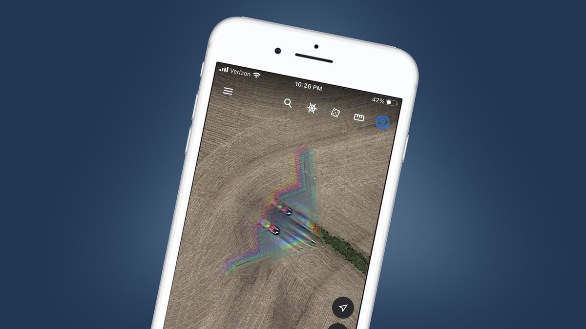
Although the B-2 Spirit can fly at 1,010 km/h (or about 628mph), an image of the bomber was nonetheless captured on Google Maps as it hurtled across a remote part of Missouri. The image was found by Redditor Hippowned.
Naturally, the image is slightly blurry and also has some red, green and blue artifacts, which are the result of how satellites capture images. Google Maps, and its software-based companion Google Earth, gather their images from a variety of sources, but this frame is credited to satellite imagery from Maxar Technologies.
Rather than focusing light onto a sensor like traditional cameras, satellites measure the intensity of certain wavelengths of light (like red, green and blue), which are then combined to make a single image.
It’s this process that’s likely behind the colorful banding seen in Google Maps’ shot of the stealth bomber, with the simultaneous motion of both the satellite and aircraft causing the psychedelic separation between the red, green and blue parts of the image.
This isn’t the first time a stealth bomber has been spotted on Google Maps; a craft was previously seen parked on the runway at Whiteman Air Force Base, the current home of the B-2 Spirit. But it is the first time one has been captured in flight, albeit in a location that’s only 25 miles north of that AFB, which goes some way to explaining why it’s seemingly hurtling towards St. Louis.
Flying colors

Google Maps has been going for over 15 years, but much of its imagery is updated every few years, which explains why new, unusual sightings frequently pop up on the service.
That said, it’s relatively unusual to see fast-moving objects like planes – and stealth bombers in particular – in its patchwork of satellite images. In 2017, Redditors discovered an airliner in mid-flight over the South Downs National Park in the UK, with that photo also displaying the same red, green and blue artifacts as the B-2 Spirit shot, but it’s still pretty rare.
Google’s method of compiling its satellite shots has also created some slightly spooky, aircraft-based anomalies. In 2019, a Google Earth user in the UK spotted what appeared to be the shadow of an aircraft under the sea, just off the coast of Edinburgh, Scotland.
But a Google spokesperson told The Mirror that “the reason it looks like the plane is underwater is because each satellite image you see on the map is actually a compilation of several images.”
The spokesperson added that “fast-moving objects, like planes, often show up in only one of the many images we use for a given area. When this happens, faint remnants of the fast-moving object can sometimes be seen.” Or in the case of the stealth bomber, a surprisingly clear shot of the one of the most recognizable aircraft ever made.
For all the latest Technology News Click Here
For the latest news and updates, follow us on Google News.